16 July 2016. We unabashedly take hikes rated as “easy” these days. Having injured both knees over the past two years, hikes labeled “moderately strenuous” are now usually just plain strenuous for us. Altitude gain doesn’t bother us too much once we are acclimated, but tough footing, disappearing trail signs, and steep descents give us cause to pause and think about how much we value our lives.
According to the book “Walking Guide Around the Alpe di Siusi,” the hike we chose for Friday, #10 for the record, was to be an easy hike. It was depicted as a round trip that was to take 2.5 hours with 214 meters of altitude gain and loss. We are slow hikers, so we figured even if it took 3 hours, we’d be fine, and there were two rifugi where we could get lunch. Piece of proverbial cake. Ha!
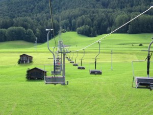
The Marinzen chairlift. Scenic, but such a cold wind this day! It goes up, up, up into the trees ahead.
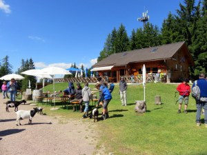
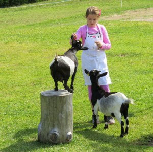
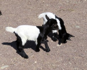
The lift to our starting point at Marinzen leaves from Castelrotto at the base of the Alpe di Siusi. Marinzen is an older chairlift. Nothing wrong with it, but it is less comfy than some others in the area. It is a long ride, about 20 minutes, and this day, in JULY no less, it was cold, about 9 degrees Celsius (48 Fahrenheit) with a biting northerly wind. Brrrrr. Once we hit the trees we were shielded from the wind and the sun came out. At the top, we found a delightful refugio with baby goats only a couple of weeks old. They (the rifugio, not the goats) served great strudel, one of the best we’ve had, and a perfect cappuccino. God, I love hiking in Italy! We could have stayed awhile, but there was a hike to do.
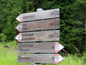
The hike starts on a gravel road then veers off across a meadow with a faint track leading to a shrine. Past the shrine is a trail sign. We knew to follow #12. The path steepened so we took out the hiking sticks. It was a steady climb, but not bad, with occasional rocky sections, nothing horrible. We are, after two weeks here, acclimated to the elevation and the level of activity. Still, as we trudged on I felt it better to go forward because I really did not want to go back down that steep trail. My knees and my nerves dislike steep descents. A couple of places it was hard to discern the exact trail but we were able to look up and spot the CAI red and white sign and determine the proper path.
Younger people were passing us by, but we persevered. Then we came to a place where the trail might have gone straight or might have taken a left steeply uphill to a set of log steps with a railing. I was tempted to go straight, but a man was coming down from the left so it seemed a good bet that was the trail. No sign, of course. The next part was navigable, although basically a deer path with a steep drop off to the right. So glad we had our hiking sticks! Up and up we went, the drop to our right so steep that a misstep would mean waving goodbye and planning a funeral. Then we encountered an avalanche of boulders blocking the trail. It looked like a landslide from a long time ago. I wanted to turn back, but knowing how challenging the ascent had been, it made me weak in the knees to even think about it. Was there a trail that continued after the boulder field? Ric bravely scrambled up to see. Yes, he thought we could make it, so grabbing handholds on the boulders and carefully placing our feet so as to not twist an ankle or take a header over the cliff, we managed to clamber over the 40 feet of boulders blocking our way. It was not something one would expect on an “easy” hike.
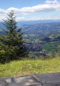
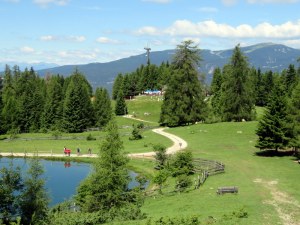
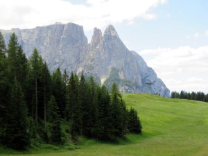
Rest stop view. By this point most of the harrowing parts were over. Looking down on the valley where Castelrotto sits.
Continuing on, now aided occasionally by some log railings to prevent a disastrous fall, at last we came to a lovely overlook with a picnic table, perfect for a rest. This was just over an hour into our supposedly 2.5-hour round trip, but we still had a long way to go. We could see the Cabinovia Alpe di Siusi and it was still a long way off. We knew our objective was past the line of the lift as it ascended. Our 1:25,000 scale hiking map showed we were past the rocky areas, but we hit one last bit of scree to navigate in an area of some water run-off then, luckily, the trail veered into the forest and the deer-path-with-a-drop-off disappeared in favor of a woody path with some rocks and roots. Relief! Eventually we joined a road and walked easily to Hotel Frommer. Walking time was about 2 hours. We are not fast, but we were moving as best we could. I think the trail is severely mislabeled at 1 hour.
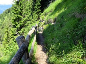
We were so concentrating on hiking that we did not take trail pictures. Oh, I wish I had a picture of the boulder field and Ric crossing it! Here, the deer path is bordered by a fence to prevent falling. Not the case everywhere along this trail
In fact, in post-hike wonderment, I went seeking more information on this trail, which was very hard to find. A source I found in Italian put this section alone at 2 hours with 400 meters of elevation change given the ups-and-downs. This is, to our point-of-view, more accurate. Ric used his altimeter app to check the altitude at several points and determined the authors just checked the altitude at Marinzen and the altitude at Frommer and did the math, not accounting for higher points along the way. Losers. Oh, and the second source rated the trail intermedio, not easy.
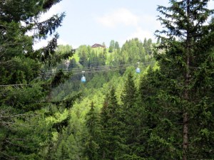
Can you see the little blue ovals? That is the cabinovia that whisks people up-and-down from the Alpe di Siusi. We are nearing the end of the hike, having passed under it.

I so enjoyed this! I’m a newbie to hiking–actually a little fresher than that, haha, and 63 to boot. It’s been on my bucket list for decades and now I figure I’d better get moving while I barely can! I’m so glad you point out that you can still hike when you get older when things get worn out–just take it a little slower! Wonderful photos and it looks like a wonderful time!
LikeLike
Welcome to hiking as a senior! The key is to just get going and keep going, putting one foot in front of the other. And cappuccino, of course!
LikeLiked by 1 person
Thank you! Of course, what’s always on my mind is. Where’s the bathroom! 😂
LikeLike
In Italy and Switzerland that’s not much of a problem!
LikeLiked by 1 person
Just want to send you a big “THANK YOU” for the information and inspiration to hike in the Dolomites. We came back from Ortisei a few weeks ago and I cannot tell you how helpful your blogs were in making our trip successful . It was truly the trip of a lifetime.
LikeLike
Kathleen, That is wonderful to hear! Please tell me, what was your favorite hike?
LikeLike
I would have to say it would be the last hike of our trip which was from the Resciesa Lift and although the day was a little hazy it was breathtaking. We took the western #35 trail to Santa Croce and the cross. By this time we were able to identify some of the mountains and had a better perspective of what we were seeing. The Odles, Val di Funes, Alpe di Suisi, Sallolungo and Sassopiatto all from one trail. Beauty beyond belief. It didn’t hurt that there was an incredible hut ,Rifugio Rasciesa, and we followed your lead stopping for strudel whenever possible. Thanks gain!!
LikeLiked by 1 person
I’m exhausted just reading about it!
LikeLike
Hi Cousin! At least it was not hot out! And that bus at the end was so welcome.
LikeLike
You had me at baby goats and strudel. We climbed Kilimanjaro three years which as difficult but now….I need spinal surgery for damaged nerve endings and like you, hate descents and scree! Up is fine. Down is evil. Would have hugged tha bus driver no matter the price. You’re both amazing.
LikeLike
Down IS evil! I used to dread the ups..now it’s the downs that kill me. Ah, aging….
LikeLike
Good articles, beautiful images, and beautiful website..Bravo
LikeLike
Oh my! The views are gorgeous but I got nervous reading until I remembered that you wrote this AFTER the hike!!! You two are brave !
LikeLike
It is a fine line between brave and stupid. Actually we had no choice once in-for-a-penny! Having been hiking daily for two weeks at least gave us the wherewithal to persevere!
LikeLike
Beautiful scenery! If I had been with you, I would have stayed to play with the baby goats until you returned. Then I would have been a wreck when you didn’t return in the time frame you said you would!
LikeLike
Those goats were a draw! Luckily there is cell phone coverage EVERYWHERE up there so we could have called you!
LikeLiked by 1 person
They need a “WTA” there. . Paul is out now repairing trails, and it’s a great website for up to date with reports on trail conditions. We do have great vistas, but maybe not as spectacular as there and much harder to find strudel! Enjoy!
LikeLike
I know! We could not believe the poor signage. Usually they are very good. Even sadder is that a map company could put out a book with such poor guidance and inaccuracies. We took another of their hikes today: 3H45M instead of the 2H30M predicted and they calculated altitude gain/loss by doing the difference between beginning and end, which was 170 M loss. But we had 45 minutes of uphill hiking between the two point. Go figure!
LikeLiked by 1 person
Glad you survived! I think I’ll stick to hiking through towns with cafes!
LikeLike
At least we have the rifugi to refresh us!
LikeLiked by 1 person
Thanks for sharing your informative experiences on the trails of the Dolomites.
LikeLike
Our pleasure! I think I need to write a book: “Hiking for old people who live at sealevel.”
LikeLike
I am not a hiker but reading about descending, I see a possibility for another hiking tool. A flat sled (like you use on snow) that you just sit down on and control your speed with your hiking poles! Of course I would suggest one has plenty of padding in place!!! :o)
LikeLike
Hahahahaha! I carry padding. 🙂
LikeLike