25 July 2015. This post may be a bore for some readers, but at least the pictures are pretty. I am writing it mostly so I have a good reference for “what I did on my summer vacation” and can remember which hikes to do and not to do next summer.
For hiking enthusiasts, especially those who are “of a certain age” this may be a reference for hikes in the Dolomites that do not require pitons, crampons, or the energy of a 30-year-old. Many of the guidebooks talk about “easy hikes” and then do not tell you about the knee-pounding descents or heart-pounding ascents, not to mention narrow trails above steep ravines and gorges. Some so-called “easy” hikes end up being 4+ hours. We can do that now-and-then, but not every day.
FYI, the pedometer readings include everything for the day, whether on the trail or walking to dinner or to get groceries.
This is an abbreviated version, believe it or not. It was a very active two weeks!
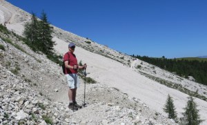
Monday, July 6 – Long way down: Rasciesa to Ortisei via Val d’Anna
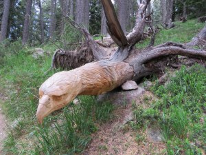
During our descent, we happened upon this carving in the middle of the forest, unsigned, a gift from a local woodcarver.
We arrived in Ortisei on Sunday afternoon in the middle of their sagra and settled in. It was HOT so we decided to take it easy with a mostly downhill hike through the forest on Monday. WRONG! We ascended via a funicolare at Rasciesa which we have done many times prior. Rather than hike the sun-exposed Rasciesa plateau in the heat and humidity, we decided to take “easy” Trail #35 east, descending on Trail #9. Bad move. It was a knee-jarring, quadriceps-pounding, mostly-exposed, slippery-rock-studded mistake. Three-and-a-half hours of downhill tromping made us wonder why we came on vacation. Now we know why we saw only mountain bikes and no other walkers. Actually, it would not have been so bad had we not missed our turn to a planned rifugio where we could have rested and had some refreshment (hiking goes better with strudel), followed by a wooded path following a burbling stream through a valley. Oh, would-that-had-happened! One sign pointed downhill to the rifugio, but when we were 100 meters down the hill, another sign pointed back the direction we had come. In frustration, and believing ourselves to be near the finish-line, we carried on, but it was another hour to the bottom. Ugh! It was a good workout in terms of calorie-burning, and at least we were in good enough shape we could still get out of bed the next morning.
Pedometer: Didn’t freaking work! Estimate 8 km for the day.
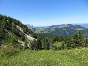
Tuesday, July 7 – Abandoning waterfalls for high ground: Monte Pana to Saltria

View from the trail to Saltria.
Planning an easy hike today, we took the bus to the village of Santa Cristina and the Monte Pana chair lift, where at the base we were to find an “easy” waterfall walk. We found the waterfalls – at least one of them – after hiking across an unsigned meadow, but no official path. Having Val Gardena Passes in hand, we could ride any of 12 lifts in the valley, so we thought we’d ride the chairlift and have a look around. Of course, we found a rifugio (really more of a hotel) at the top of the lift, so over a cappuccino we pondered our options. There was a bambini trail, but that seemed too silly. Saltria, a location we know well, was purported to be a hike of 1h:45m so off we went, knowing that at the end we would find a hotel with a nice café and a bus to Compatsch, followed by a
Cute little Santa Cristina.
dramatic cableway descent and a comfy bus back to Ortisei. This hike, for the record, followed Trail #30A through mostly wooded terrain to Trail #18, which leads to Saltria. There were a few nice viewpoints, and some sun exposure although mostly at the start and finish. Hot and humid, so we had quite a trek…not the easy waterfall walk we had planned but an easy enough hour-and-forty-five. The Alpe di Siusi was having a record heat wave and this was the second consecutive 36-degree Celsius day. I felt sorry for the little ponies at Compatsch who had to stand in the sun waiting for tourists to go on carriage rides. Brutal for them! The cows did not seem to mind the weather.
Pedometer: 18,766 steps; 10.3 km
Thursday, July 9 – Cool at last: Ciampinoi to Passo Sella
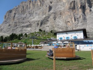
Snuggled up against the Sassolungo, there is a vast terrace and lawn. The seating pods swivel on their bases.
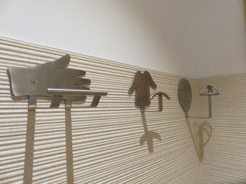
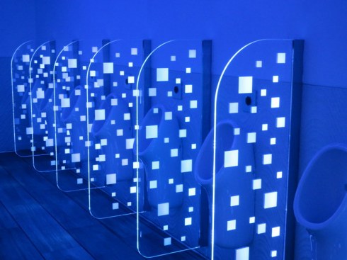
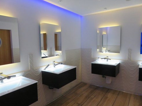
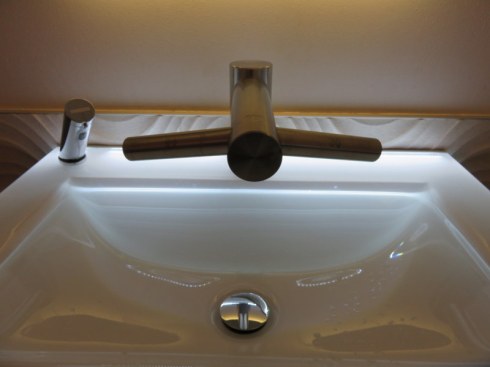
It was a pleasant 10 C/50 F at the top of the lift. Jackets required! Sunny and clear, hiking sticks at the ready, we headed off to Rifugio Emilio Comici, our first stop, which turned out to be a gem. The rifugio is tucked up under the Sassolungo, modern, with an enormous terrace, a generous lawn with sun chairs, and the cutest pods for lounging and dining. It also has THE BEST bathrooms, employing technology at every turn and clean as the proverbial whistle. Heading off after a perfect espresso and, for me, yogurt with 4 kinds of fresh berries, we completed our hike to the large hotel at Passo Sella, complete with bar (serving strudel of course), restaurant, and the strangest lift we’ve ever seen. The “cable cars” looked like flying refrigerators and we took one up to the VERY high Rifugio Toni Demetz. Click on any picture to enlarge and view the slide show.

Cable cars ascending, as viewed from the trail.

Ric is in #42, a few meters behind me.

The strange cable cars of the Sassolungo.

Looking back toward the Passo Sella.

Unbelievable ride in the flying refrigerators! There were many people actually climbing up.

The other side of the mountain. View from Rifugio Toni Demetz looking west.
The Sella Pass is at 2244 meters/7362 feet, and the rifugio is at 2685 meters/8809 feet. One cannot merely step into one of the refrigerator lifts, one is bodily thrown in by two young, strong men who use a firm grip to propel you and slam the door firmly behind you before you can change your mind. At the other end, they pull you out and thrust you off to the side to avoid being hit by incoming cars. Repeat upon return. Ric and I did not understand the drill as when we arrived there was no line, so we did not manage to get into the same compartment. We rode separately, waving from time-to-time across a divide of a few meters. On the way down we managed to get thrust into the same car. For the record, we took Trail #21 to Comici and #526 to Passo Sella.
One can continue to hike from Passo Sella, or return via the same route, but we opted for lunch at the very nice restaurant, then took a bus (included in the free bus card most lodging establishments give you) back to Ortisei.
Pedometer: 20,815 steps; 11.5 km
Friday July 10 – Same but different: Ciampinoi to Mont Seüra

Trail side company.
Thursday provided exactly the type of hike we like: clear, cool weather, glorious scenery, long enough but not too long, good exercise, fabulous photo ops, food in the middle and at the end, and good transportation. (A loop hike or one with good transportation is ever more desirable than an out-and-back.) We liked Thursday’s hike so much that we returned to Ciampinoi and this time headed west, opposite of the prior day. Rifugio Emilio Comici was on the way, so we knew exactly where second-breakfast was to be found. With our trusty map in hand, we set out from Comici intending to take #526B to Mont Seüra. We ended up on #526A (a harder trail) because we missed a tiny little turn onto a short portion of #528 that led to #526B, sooooo we ended up on a hike across a scree field that was 1¼ hours longer than planned. And we had not even had strudel! The final section of the hike was across a beautiful meadow with a killer view of the Alpe di Siusi in the distance, and since we survived, I have no complaints.
Pedometer: 18,926; 10.4 km
Ric hikes across the unexpected field of scree. We were supposed to be in the meadow below.
From Mont Seura, view of the Alpe di Siusi, largest high-alpine meadow in Europe.
Sunday July 12 – Witch hunt: Fiè to Castello di Presule
Once upon a time, this area witnessed the persecution of nine women judged to be witches. In the 16th century, they were tortured and burned, source of the so-called Schlernhexen stories. Today, the emblem of a witch on a broom is used in marketing the area to tourists, enticing them with the natural beauty. Go figure.
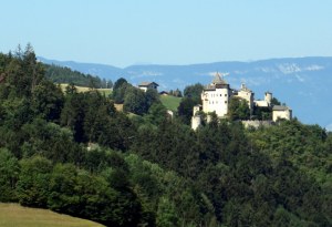
Castello Presule from early in the hike.
We started with a bus ride from Ortisei to Fiè, about 45 minutes. Although one can actually take a bus to the village of Presule and visit the castle, we had not hiked below the Sciliar (German: Schlern) on this side, the west side, and were drawn by what we thought would be a shady hike. It was about 50% exposed to the sun, so not bad. Nothing spectacular but nice enough, with some good views of the castle. We were too close to the mountain to see it, though.
Arriving at the castle, we missed the English tour by 10 minutes and the next one was 3 hours off. We settled for coffee in the shade. This was one of those locations that makes you shake your head in wonder. There was a castle here as early as 1200. The current one dates to the early 16th century. Yet there is a tiny coffee bar where a nice lady pulls good shots into ceramic cups and dispenses directions on bus routes and schedules. There was a nice shady picnic area to lounge in before hiking 20 minutes downhill to wait for a bus back to Ortisei, where we arrived in time for lunch. Not a bad outing on a day that was getting too hot for hiking comfort.

These cornstalks looked like they were dancing.

Trail side wildlife; Fie’ is in the distance.

Castello Presule.

The shady grove for picnicking at the castle.

Even at the castle, a tiny bar where one can get a nice espresso in a ceramic cup.
Pedometer: 17,835; 9.8 km
Monday July 13 – Giorno di riposo: Shopping in Bolzano
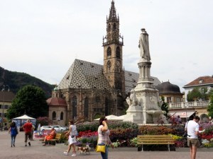
Piazza Walther, Bolzano
In a longer trip, taking a day off (giorno di riposo) is a nice change of pace. No hiking and no sightseeing, just a morning shopping expedition in Bolzano, followed by a fabulous lunch at a very inventive new restaurant in Ortisei, and an afternoon of relaxing, reading, writing, organizing photos, and so on. So relaxing we didn’t even go out to dinner.
In fact, on this trip we decided to prepare meals in more often. After all, we’re retired and we have time! The result of cooking a few simple meals was a savings of about Euro 400.00 over what we would normally spend in two weeks of travel. Niente male!
Pedometer: 10,304; 5.7 km
Tuesday July 14 – Harder than we thought: Rasciesa to Malga Brogules
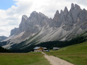
Little Rifugio Malga Brogules, beneath the Seceda Plateau, Puez-Odle.
Back to Rasciesa, from the funicolare we headed east, opposite of our hike on Saturday. This was labeled an easy hike by some source or another. I’d say it had nothing technical, but there was a VERY steep downhill at the beginning, along a path of set stone (Appia Antica style, but less level and with a significant downhill grade) which required one to watch every step. So happy to have my hiking sticks! I have become a very cautious hiker since injuring my knee in a fall in Roma last March. The knee is still a bit grumpy, though not painful, and the thought of re-injury makes me shudder. This trail (#35) also has a very steep descent to the rifugio Malga Brogules, about a kilometer of the same type of stone path. There was no turning back as the thoughts of a bathroom and espresso were front-of-mind. It was, however, the longest kilometer I have ever walked.

As we hiked toward Brogules, we encountered this construction equipment exiting. It must have taken HOURS as they went no faster than a person can walk.

Most of this hike was above the tree line.

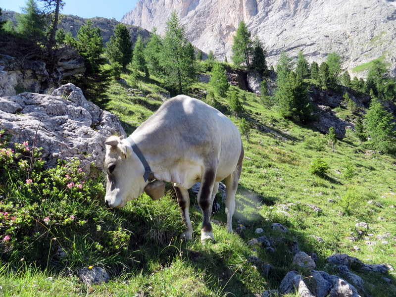
I love this picture of Ric hiking through the cows towards the Puez-Odle group.

Horses also frequented the path.

Nice wide path means you can walk alongside each other most of the way. And allows construction equipment to pass.

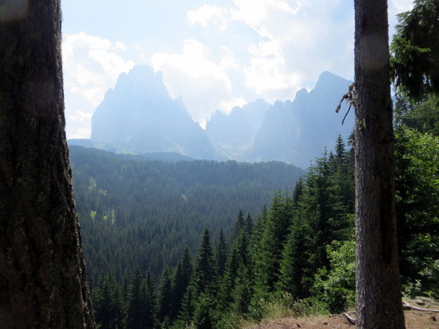
View of the dramatic Puez-Odle group.
This rifugio was under major renovation and I feared would be out-of-service. Luckily, in the spirit of true mountain hospitality they had table service and freshly-baked strudel as well as a sparkling clean facility. Retracing our steps on this out-and-back hike we found climbing the steep sections of paving stones much easier than descending them. This was a 4h:10m hike altogether, with a ½ hour stop at the rifugio and a couple of brief water/rest stops along the way.
Pedometer: 24,005; 13.2 km
Friday July 17 – Friends in high places: Hiking Piz Sorega
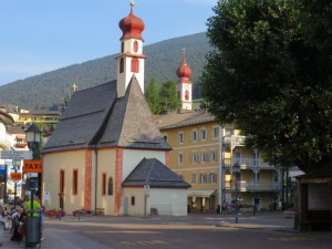
Ortisei in the morning. The two steeples look the same size from this perspective, but the closer one is a fraction of the size of the big church on the hill.
Our friend Marjory was staying in San Cassiano in the Alta Badia, so we headed over the Passo Gardena to meet her. Holy cow, what a bus trip! Fabulous scenery and so happy I did not have to drive so I could look at the view! We had promised ourselves that with two weeks in Ortisei we would take some time to explore neighboring valleys we had heard about: The Val Badia, Val di Fassa, etc. (We made it to the Val Pusteria in June.) Here we are, two days from end-of-trip when we finally head over the pass to expand our horizons.
The Alta Badia is fabulous, too. We were impressed with the mountains that are just the other side of the Sella Group from the Val Gardena. Marjory scouted out a lovely hike and we could see the potential for a lot of exploring just from the top of the lift at Piz Sorega, and there are many other towns in this little enclave that beg exploration as well. I think a small side trip is in order for 2016. Thanks for the introduction to the A.B. Marjory!
Pedometer: 14,859; 8.2 km

Marjory & Me.

The Alta Badia, simply beautiful!

A view of the Marmolada from Piz Sorega. Note the giant wooden sunbeds. Quite a view for high altitude sun bathers.

This is the pl;ay area/wading pool at a rifugio.

One of the Alta Badia peaks above San Cassiano, towers over the path.

Another beautiful view.
Saturday July 18 – Last day hike: Mont Seuc to Monte Piz and back
We have fond memories of our Christmas Day hike, so we did about half of it, returning to Mont Seuc after coffee at Hotel Icaro. It was an easy hike across to Icaro. We returned via Sole so we could take the chairlift to make an easy morning. Lots of people out, and thank God it was cooler due to rain the night before. In fact, we had a terrific thunderstorm. We would have expected at least two each week, but only had one good one. No doubt a result of the wacky summer weather: climate change in action. I am worried for our planet.
Pedometer17,952; 9.9 km
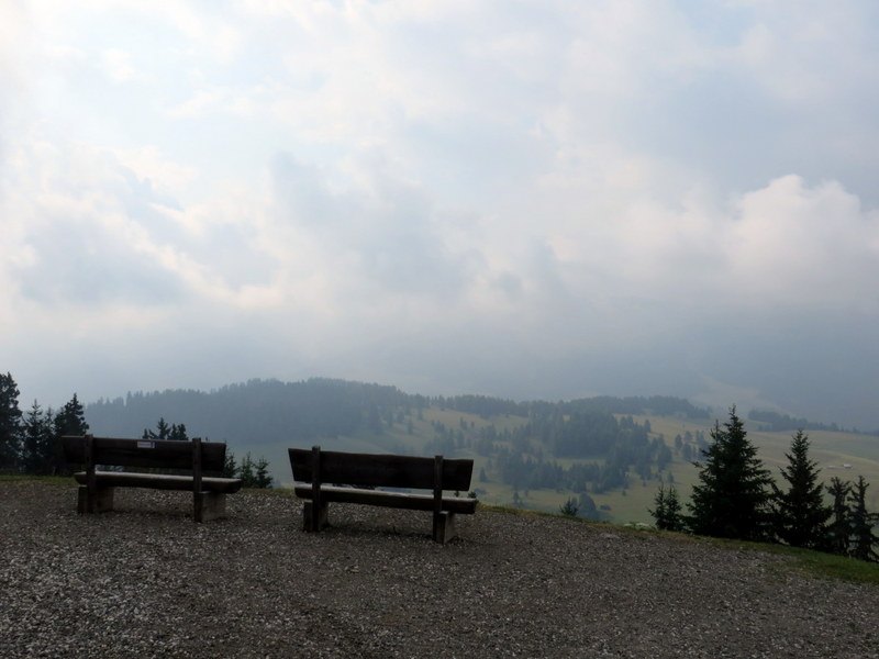
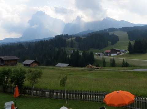
Three years ago I took this picture from Mont Seuc, looking toward the Sassolungo & Sasso Piatto.
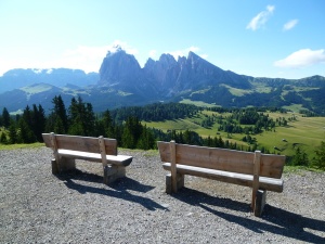
Hopeful benches, 2012. This is the view that made me fall in love with the Val Gardena.
Same location in 2015
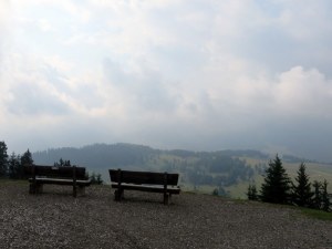
Same benches, three years later, but today we are in the clouds!
Tags: Alpe di Siusi, Ciampinoi, dolomites, Hiking, ortisei, Passo Sella, Rasciesa, Rifugio, Rifugio Emilio Comici, Val Gardenia