Plans have a way of changing and my winter project was not going to be updati hiking guides. Motivated by new experiences and changes we encountered and fresh perspectives (who says repeat visits to the same location are boring?) it seemed beneficial to issue new-for-2023 editions. (NOTE: Both books were updated in January 2025 and the links below were updated as well.)
The Val Gardena book now includes some ideas for rainy days as well as for lazier days without hiking. There are also extensions and options to some hikes for increased activity and where possible, and details on where shorter hikes can be linked together for longer excursions.
For Switzerland, there s a new chapter on rainy day ideas since we had about 10 days of cloudy and damp conditions during our late-season stay in 2022. We still found plenty of fun things to do. Some of teh hikes have been tweaked based on 2022 experiences.
In each book, all URLs and maps are up-to-date.
This is a great time of year for planning a summer or fall hiking trip to either Italy’s Val Gardena or Switzerland’s Berner Oberland.
The other day we went for late morning coffee in the cute village center. We had decided to not go up high on a hike but to chill a bit ad do some shopping since the day prior was quite active. After a couple of grocery store stops, Ric realized he did not have his wallet. A frenzied search of the apartment led us to return to the last place we knew he used his credit card: a grocery store here in town late the afternoon of the day prior. No, they had not recovered it. Worried about compromise, Ric checked the two credit card accounts and two bank accounts for which cards had been lost. His driver’s license was also in the wallet which was actually a small folio for a few cards and cash. Goodnews: no unrecognized activity. Bad news: Ric had to cancel all of the cards which meant I was the only one with access to funds of any sort.
For a leisurely day, it was intense. We went three times to Ortisei center. We are staying up a hill a 10 minute walk from town center which doesn’t sound bad until the third uphill return.
After all of the efforts to cancel cards were complete, our landlady, Justine, rang our bell at 4:30 PM to tell us il portofoglio had been found at the café where we’d had coffee about 10:30!
Two young waiters had spent the day trying to track down Ric. They tried Facebook, Instagram, and God-knows-what other networks with no luck because Ric isn’t connected online. Finally, they called the Tourist Information Office who sent out a blast email to all lodging facilities in Ortisei. Did anyone have a guest “Ric di Oregon?” Luckily, Justine was at her computer and saw it.
The view from our table at Cafe Demetz, Ortisei. The wallet was found on the floor under our table.
We headed into the village center for the FOURTH TIME to retrieve the wallet and reward the guys. Everything was intact: all 4 cards, driver’s license, health insurance card, and about €50. Remarkable! This is such a small town that all the locals know each other despite hosting more lodging beds than there are residents. Such good news, the kindness and honesty of strangers.
The timing was just right for un’aperitivo served by the very guys who found the wallet. That eased us into the evening and we ended the day on a true high with great pizza and our favorite local wine, LaGrein, at the pizzeria next door.
Another view, in the evening with Aperol Spritz and a small bite.
Charles Schwab Bank is expressing a replacement debit card to Ric, but the credit card companies wouldn’t do that so I will be paying for most everything since cash is used less and less here as at home.
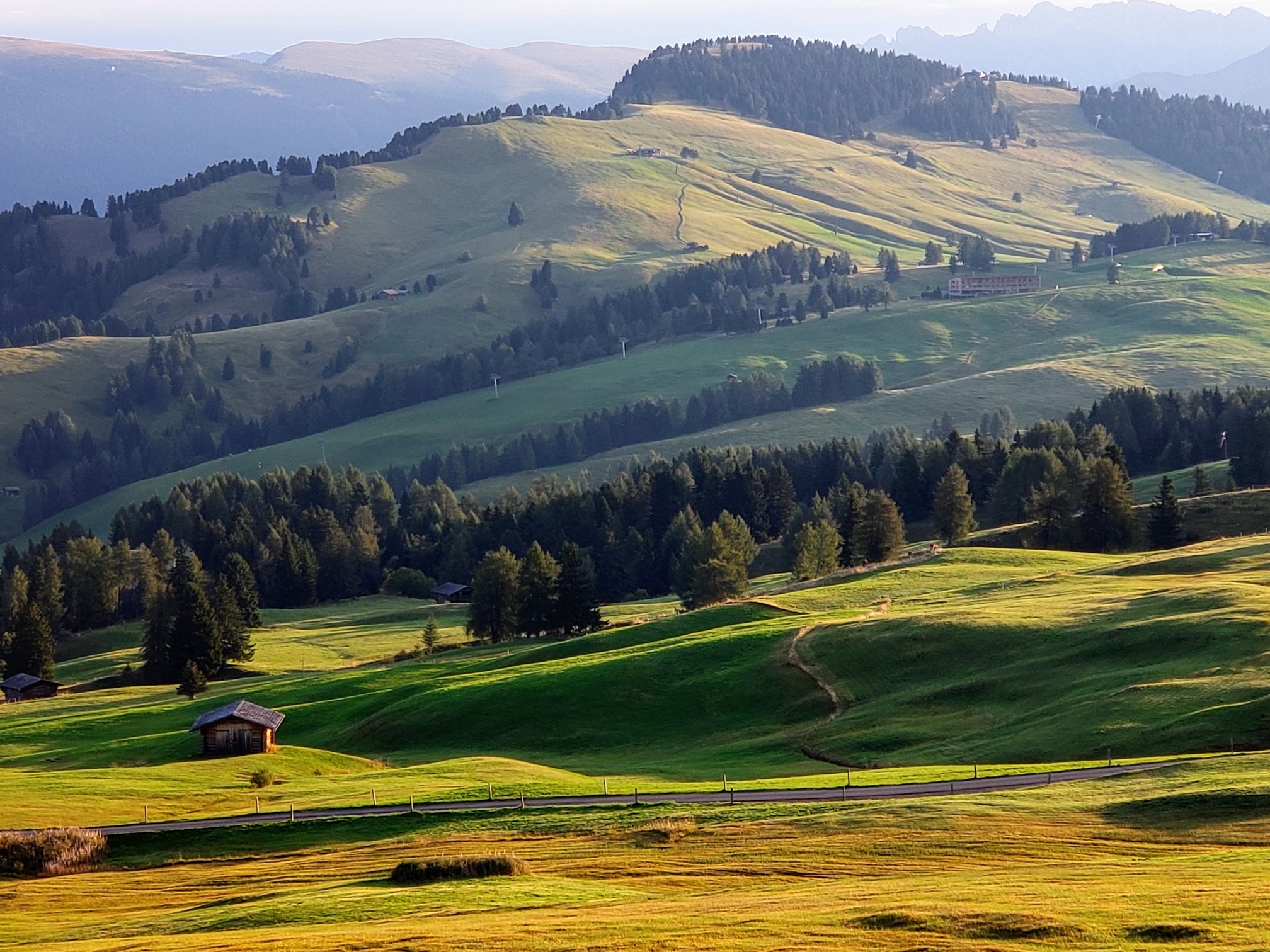
On another note, hiking has been excellent as the weather has been near perfect. We eased into mountain hiking with a few nights in the Alpe di Siusi where there are many paths and roads for walking that are fairly gentle and undulating. No need to take strenuous ascents and descents unless you want to. We didn’t even unpack our trekking sticks there.
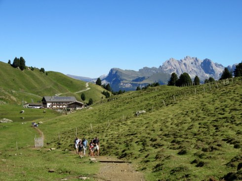
We embarked a couple of days ago on an old favorite in the Val Gardena. We had not taken it since 2019 and 3 years made it seem a wee bit harder on the creaky old knees and hips.
I am contemplating a book update for 2023 after all. More hikes to add and tweaks to make aimed at other creaky-kneed hikers. We’ll see. Editing is such a job.
Frankfurt is an easy city to dismiss. We have merely passed through on flights a couple of times, landing one afternoon and leaving the next morning. In 2016, we spent a full day and self-guided using a tour in the Rick Steves’ guidebook. This time, we decided to spend two nights and take a tour with the highly recommended Jo of Frankfurt On Foot Tours.
There is far more to Frankfurt than the thru-traveler using it as a waypoint would know. Jo filled us in not only on the long and important history as a merchant city, but on current culture and the changing face of the city. After a fabulous 3-plus hours, we were exhausted but informed. We have learned over the years that a great private tour is an excellent way to get insight into a site or a city. Worth every Euro.
Frankfurt: old and new. And hot.
The reason we pass through Frankfurt so often is that there are non-stop flights from the West Coast on Condor Air that make for relatively painless travel, if 10 hours can be painless. Changing planes on the East Coast is a trial we’d rather not endure ever again whether coming or going. Far better to make a single hop to FRA and then jump on a train to our next location after a good night’s sleep. Having a favorite Italian restaurant there doesn’t hurt.
As to sleep, I had a few bad nights prior to departure with so many pre-trip things on my mind: Will Sven and Molly have separation anxiety? Will I have separation anxiety? Will Sven and Molly forget who we are after 2 months? Will our bags arrive or be cast onto a pile of 5000 others as we have heard in reports? Derek’s surgery, new house sitter to get organized for, third heat wave hitting this weekend: Good Lord, no wonder I was stressed! Oh, and then COVID hanging on. I packed a pile of masks because, sensibly, the Germans and Italians are still requiring them on public transportation. That included our German airline. Everyone was masked-up except when eating.
Speaking of Beyond the Guidebook, we are NOT updating the guidebooks this year. (THAT was a weak segue.) I wanted a trip where I was truly relaxing, not making notes and taking photos, and then spending the winter laboring over edits. I don’t envy the Rick Steves’ editors. It is a LOT of work checking and cross-checking details for a new edition.
This year is a true vacation and I will post discoveries on the blog instead of updating the books.
Click on any photo for a better view. The landscapes are stunning!
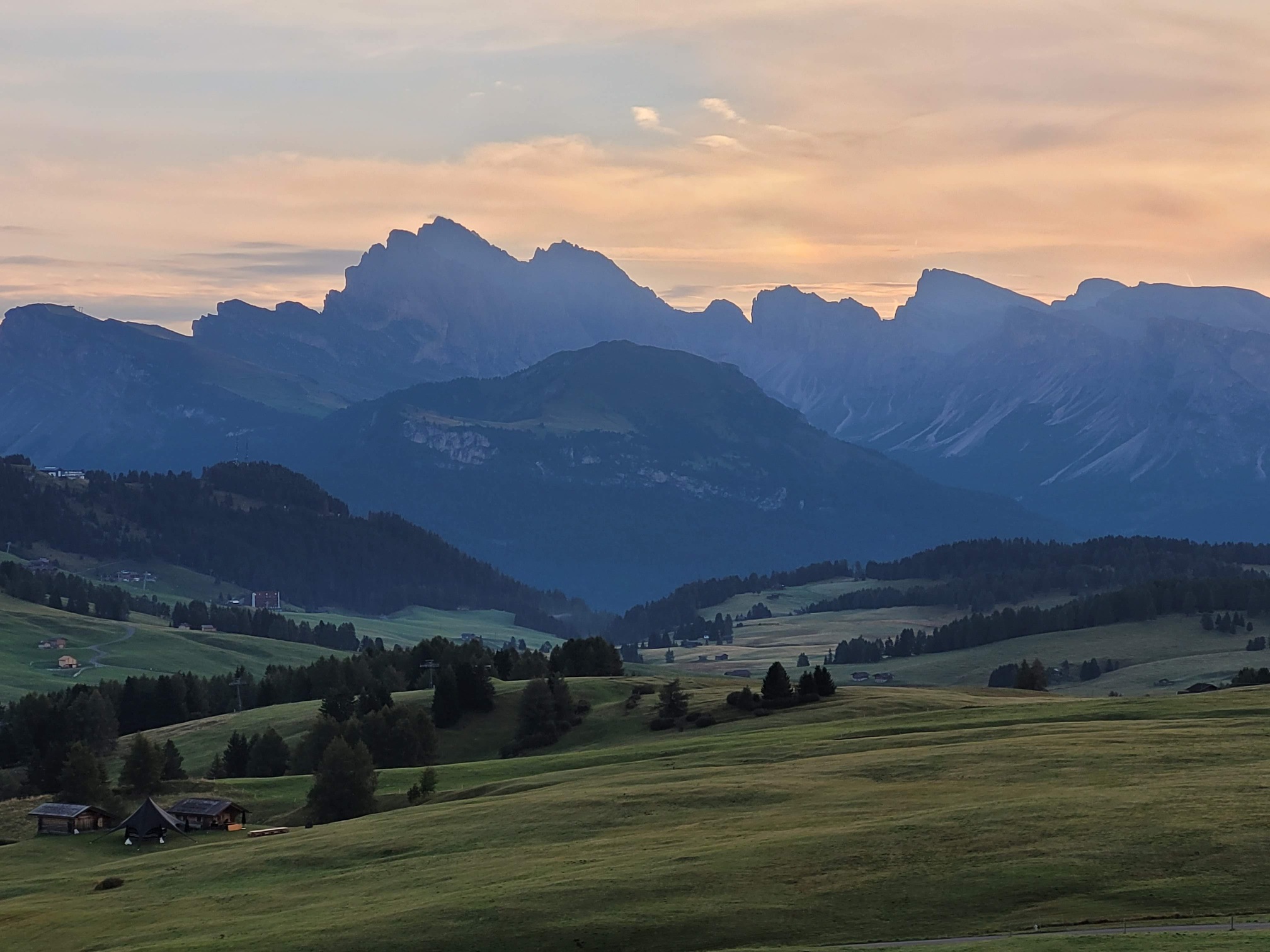
Clockwisefromtopleft:Morning light on the Alpe di Siusi; The Denti di Terrarossa above the Alpe; Before sunrise in the Alpe di Siusi; One of our many companions on a morning hike; Me fashionably dressed for the German trains; Long view on the Alpe to our hotel with the Sciliar and Punto Santander; The many faces of the Alpe di Siusi include forested sections; Center, pet alpacas at the AlpenHotel Panorama.
Thursday was a long train day traveling from Frankfurt to Munich where we changed trains for the journey south to Bolzano.
Our trusty driver, Ivan, picked us up and ferried us to the Alpe di Siusi where we nestled in to the AlpenHotel Panorama, a favorite spot on our Favorite Places Tour, for three nights. This is another Beyond the Guidebook place. The other guests — mostly Italians — are surprised to find Americans here, especially on a repeat visit. It is not in any guidebook I have ever consulted but it is in our own Walking in Italy’s Val Gardena. One of the best features: rooms include not only breakfast but a 5 course dinner. No cooking, no thinking about it, elegant, tasty, and many choices. We are never disappointed.
Fun story. We first met “Taxi Ivan,” as his business is called, in 2016 when we vacationed in the Val Gardena with our two cats, traveling from Rome to beat the heat for the month of July. (See Training Cats from July 2016.) We used to take a bus to Ortisei from Bolzano, but imagine getting on a bus — even a nice one — with 4 suitcases and two cats! Taxi Ivan rescued us and we have been using his services ever since.
Hope you will stay tuned as we continue our Favorite Places Tour.
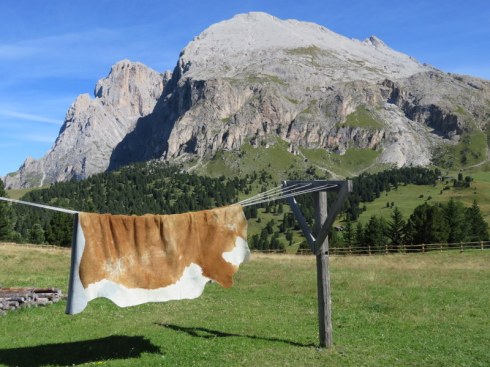
Perhaps I should repurpose my worn out boots like this Swiss gardener did.
EDITORS NOTE: These books wereupdated in 2025. Here are the links to the current editions, US site. Walking in Italy’s Val Gardena and Walking in Switzerland’s Berner Oberland . If you are purchasing from another market (UK, DE, etc.) please go to your country’s page and be sure to look for the 2025 editions.
1.2 million steps.That’s what my Fitbit logged on our trip last fall to update our two easy-hiking books. Converting that to miles, between 400-480 miles in 10 weeks.
No wonder I needed a new pair of hiking boots when we got home.
Those steps have come to fruition at last: the 2nd edition of Walking in Switzerland’s Berner Oberland (updated link to th edition in Jan 2025) and the 4th edition of Walking in Italy’s Val Gardena are now available on Amazon in all markets worldwide in Kindle and in paperback. (These URLs are to the US site. Listed below are links to the sites for the United Kingdom, Canada, and Australia. Please search your country’s Amazon site – Italy, Germany, Japan, 4India, etc. – if you are buying elsewhere.)
The Val Gardena bookstill features 23 hikes and minimal changes were made in this edition. We checked the local information and retook many of the hikes, rechecked URLs, transportation, cost of passes, and so on. For those with earlier versions, there are not a lot of changes and significant ones are noted on our updates page at ProjectEasyHiker.com.
An outing not in the book is one we call “A Path to Lunch,” an easy but satisfying outing in the Val Gardena that can be split into two shorter walks.
Seven new hikes were added to the Berner Oberland book for a new total of 20 outings. We spent 28 nights researching in the area last fall and never ran out of ideas for easy hikes. While the new book is the only place we’ve written up all of the new hikes, updates to walks featured in the first edition are on ProjectEasyHiker.com.
All of the hikes in both books feature maps and all of the maps are available to download to your mobile device.
Most notable this visit versus our last trip in 2019, there are now great apps for transportation in both Switzerland and the Südtirol. The SBB app links travelers to all modes of transportation: train, bus, boat, and mountain lifts with an interconnected route planner. It is also an easy platform for buying tickets on the go.
In the Südtirol, the südtirolmobil app offers timetables and a trip planner that are invaluable when you are on-the-go.
As always, we are happy to answer questions and get your feedback. Please drop us a note at ProjectEasyHiker@gmail.com.
NOTE: In January 2025, “Walking in Italy’s Val Gardena” was published in its 6th edition and the link to Amazon was updated.
As the clouds, rain, fog, and cold temperatures descend on the Oregon Coast, I am thinking about a wonderful hike we took in September and looking forward to a repeat next September.
We pushed ourselves a bit in taking this hike as it is more ambitious than our usual fare. We reveled in our satisfaction at completing it and celebrated with a Radler over lunch. Rick Steves’ Italy guidebook sucked drew us to this hike but his directions and time estimates were terrible. (His 1H30M section was our 2H25M. We would have taken the hike anyway however an hour’s difference in the estimated time is disappointing.) I think it has been many years since anyone in the Steves’ organization took this route and updated directions.
So we did it.
Click here to buy on Amazon.com. Also available on all Amazon sites worldwide in Kindle or paperback versions.
I would include this in the next edition of our book (coming in early 2020!), but it is a little beyond the “easy hiker” scale so I offer it here, for anyone who might enjoy the option. We spent the nights before and after on the Alpe di Siusi, enjoying the luxury of half-pension at the Hotel Saltria. This hike can be done as a day trip from Ortisei, but it is a long day, at least 10 hours with transportation. We recommend a couple of nights on the Alpe di Siusi as part of a holiday in the area. Two or three nights on the Alpe di Siusi plus four or more nights in Ortisei is perfect.
Herewith, this magnificent hike as we would write it for the book. Start dreaming of an Italian hiking trip! If you are not into hiking or cannot imagine doing this, at least look at the pictures?
Panorama to Williamshütte: A grand view on the Alpe di Siusi
The route map with profile can be examined in detail and downloaded at Plotaroute. (We will be including maps for most walks in our next edition.)
Featuring: Vast meadows, peak views near-and-far, cows, ponies, wildflowers, two dramatic chairlifts, and lovely rifugi where you can rest and refuel. The best time to take this hike is from mid-June to mid-October but be aware there can be snow in high elevations at any time which may compromise your ability to do this hike.
This hike is more strenuous than most of those in our book, Walking in Italy’s Val Gardena. In fact, we rated it a “4” on the Easy Hiker Scale* due to the varying terrain of the final two-thirds. While it starts and ends at about the same altitude, the ups-and-downs are considerable, and you will ascend 1253 feet/382 meters and descend 978 feet/298 meters.
How to arrive: Six times each day the bus #4 from Piazza Sant’Antonio goes directly to the base station of the Cabinovia Alpe di Siusi/Seiser Alm Bahn. This is your most efficient choice at 8:45, 10:00, 11:15, 14:50. 16:00, and 17:15. Note the cabinovia may not be running if you arrive on the last bus. Later in the day, use a combination of bus #172 to the bus plaza in Castelrotto and the #170 to Bivio Cabinovia (drops you a short way below the lift station and you walk up) or the combination of bus #172 and #2/3 which takes you right to the base station. Ask locally if you are confused. The bus drivers are fantastic and the route is included with the Val Gardena Mobile Card provided by your lodging host.
(NB: Bus numbers, routes, and schedules tend to be adjusted seasonally so verify times before setting out on your adventure!)
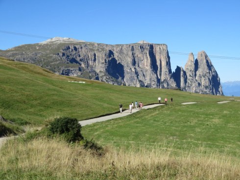
The path is wide and level as it leaves Panorama with the Sciliar and Punto Santner in view.
FYI, driving to the Alpe di Siusi is possible only before 9:00 and after 17:00 unless you have a hotel reservation and a permit for your vehicle. If you have a permit from your hotel, you can drive in at any time on your arrival day and out on your departure day, but during your stay you may only use your car before 10:00 and after 17:00. The buses are excellent, though, and parking is limited so go with the flow and take the #11 shuttle! Once at the base station (where there is lots of parking if needed), take the blue gondolas up to Compatsch where the hike begins with another lift, to Panorama. The Cabinovia Alpe di Siusi starts running at 8:00 from late May to early November. Note there are seasonal closures before-and-after ski season commences. Last ride down is 19:00! (Check locally to make sure that has not changed.)
Make your way to the base station for the Panorama lift (opens at 8:30), about a 5 minute walk down from Compatsch. At the top of the lift, pass the Alpenhotel Panorama and look for Trail #2, the start of this journey.
Mountains on the other side of the Val Gardena are visible from the trail near Edelweiss Hütte.
The route
Trail #2 joins Trail #7 in short order. Turn right and follow Trail #7 with magnificent views of the Sciliar and Punto Santner to the west. Trail #7 is a road, more up than down, but it is not steep and undulates pleasantly on your way to Rifugio Molignon, aka Mahlknecht Hütte. There’s plenty of room to walk abreast and footing is easy. We rate the section from Panorama to Molignon a “2” on the Easy Hiker Scale.*
Coming into Molignon, a perfect stop for strudel.
Moligon is a delightful place to stop although you may choose instead Edelweiss Hütte or Almrosenhütte as you pass them. Molignon is about 1H20M (depending on how often you stop to take pictures) from the Alpenhotel Panorama at the top of the lift. We usually arrive about 10:30 and use Molignon as a coffee/strudel/bathroom stop. Marvel that real ceramic dishes, stainless tableware, and actual glasses are used to serve housemade food, hot, fresh, tasty. Have a late morning beer like many of the locals do. Cyclists also stop here also and will head off on 8A as they are prohibited on the next section of Trail #7, but you’ll see many of them again at Dialer and some go all the way to Zallinger so you will share the path on occasion.
Leaving Molignon, which is a working farm as well as rifugio.
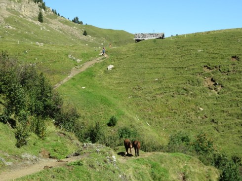
After Molignon the path becomes a true trail.
From Molignon, pass through the gate and walk past the pond, horse corral, and pasture with a herd of cows. Now the trail becomes more of a hike. You will pass over a couple of small streams, one with a bridge and one with stepping stones. Expect some dampness and mud if it has rained recently. Climbing fairly steadily, you will briefly rejoin the road (with cyclists) and reach Dialer, the highest point on the route. The chapel of Dialer Kirchl sits picturesquely against the backdrop of the Sciliar-Catinaccio.
The little church at Dialer.
Take a moment to savor the setting and maybe visit the chapel, then continue on Trail #7, following signs to Zallinger. The trail goes in and out of forests and the pavement varies. There are full-on views of the Sassopiatto’s flat face and occasionally a glimpse of Saltria far below. There is another tiny stream to cross. At one point, it appears you might need to hike up a steep gravel road but look for the sign on your left indicating #7 to Zallinger and follow it slightly down, then undulating, and at one point falling to a creek (with bridge). Finally, pass a farm and hike steadily up to the beckoning rifugio.
One of the bridges crossing a creek.
]
Zallinger comes into view!
And what a refuge it is after this long hike! It is only 10-15 minutes to Williamshütte and the Florian chairlift down to Saltria but Zallinger offers some of the best views possible from their terrace and the food is praise-worthy, ranging from gourmet salads (try the fitness salad with turkey) to Weiner-Schnitzel or the local canaderli. Of course, there’s beer and where there is beer, a Radler is possible as well.
The Sassopiatto looks a lot different from this angle.
Refueled and rested, make your way up up up to Williamshütte (15 minutes) and the dramatic chairlift down to Saltria. From Saltria, the #11 shuttle runs roughly every half-hour to Compatsch. The last bus is at 18:55 from mid-June until mid-September, then for the next month the last bus is at 17:35. Check locally to make certain you know when the last bus departs as well as being informed about the last gondola down from Compatsch!
* Easy Hiker Scale
Promenade – Paved or partly paved and mostly level; well-signed and generally suitable for baby carriages
Easy hike – Unpaved, crossing hills or mountain terrain, some ups and downs, or may have minimal signage
Extra Energy – More exertion required due to length or extended uphill segments; may have loose gravel or moderately tricky footing
Moderately Strenuous – Longer, more challenging terrain requiring sturdy footwear and endurance. Not suitable for very young children.
Logistics
Start:
Mountain station of the Panorama chairlift at Alpenhotel Panorama, Alpe di SIusi
End:
Williamshütte, mountain station for the Florian chairlift to Saltria
Duration:
3H 45M
Difficulty:
4*
Distance:
10.1KM, 6.3 miles
Type of Hike:
One-way with return by bus
Trail #s:
2, 7
Transportation:
Bus #4 or combination of #172 and #170 from Ortisei to Cabinovia Alpe di Siusi, then 3 lifts: the Cabinovia AdS, Panorama, and Florian. Return to Compatsch by #11 Saltria Shuttle. See links to schedules below.
Refreshments:
Compatsch restaurants, Hotel Panorama, Edelweiss Hütte or Almrosenhütte, Rifugio Molignon, Zallinger, Williamshütte
WCs:
Compatsch restaurants, Hotel Panorama, Edelweiss Hütte or Almrosenhütte, Rifugio Molignon, Zallinger, Williamshütte