
NOTE: In January 2025, “Walking in Italy’s Val Gardena” was published in its 6th edition and the link to Amazon was updated.
As the clouds, rain, fog, and cold temperatures descend on the Oregon Coast, I am thinking about a wonderful hike we took in September and looking forward to a repeat next September.
We pushed ourselves a bit in taking this hike as it is more ambitious than our usual fare. We reveled in our satisfaction at completing it and celebrated with a Radler over lunch. Rick Steves’ Italy guidebook sucked drew us to this hike but his directions and time estimates were terrible. (His 1H30M section was our 2H25M. We would have taken the hike anyway however an hour’s difference in the estimated time is disappointing.) I think it has been many years since anyone in the Steves’ organization took this route and updated directions.
So we did it.

I would include this in the next edition of our book (coming in early 2020!), but it is a little beyond the “easy hiker” scale so I offer it here, for anyone who might enjoy the option. We spent the nights before and after on the Alpe di Siusi, enjoying the luxury of half-pension at the Hotel Saltria. This hike can be done as a day trip from Ortisei, but it is a long day, at least 10 hours with transportation. We recommend a couple of nights on the Alpe di Siusi as part of a holiday in the area. Two or three nights on the Alpe di Siusi plus four or more nights in Ortisei is perfect.
Herewith, this magnificent hike as we would write it for the book. Start dreaming of an Italian hiking trip! If you are not into hiking or cannot imagine doing this, at least look at the pictures?
Panorama to Williamshütte: A grand view on the Alpe di Siusi

The route map with profile can be examined in detail and downloaded at Plotaroute. (We will be including maps for most walks in our next edition.)
Featuring: Vast meadows, peak views near-and-far, cows, ponies, wildflowers, two dramatic chairlifts, and lovely rifugi where you can rest and refuel. The best time to take this hike is from mid-June to mid-October but be aware there can be snow in high elevations at any time which may compromise your ability to do this hike.
This hike is more strenuous than most of those in our book, Walking in Italy’s Val Gardena. In fact, we rated it a “4” on the Easy Hiker Scale* due to the varying terrain of the final two-thirds. While it starts and ends at about the same altitude, the ups-and-downs are considerable, and you will ascend 1253 feet/382 meters and descend 978 feet/298 meters.
How to arrive: Six times each day the bus #4 from Piazza Sant’Antonio goes directly to the base station of the Cabinovia Alpe di Siusi/Seiser Alm Bahn. This is your most efficient choice at 8:45, 10:00, 11:15, 14:50. 16:00, and 17:15. Note the cabinovia may not be running if you arrive on the last bus. Later in the day, use a combination of bus #172 to the bus plaza in Castelrotto and the #170 to Bivio Cabinovia (drops you a short way below the lift station and you walk up) or the combination of bus #172 and #2/3 which takes you right to the base station. Ask locally if you are confused. The bus drivers are fantastic and the route is included with the Val Gardena Mobile Card provided by your lodging host.
(NB: Bus numbers, routes, and schedules tend to be adjusted seasonally so verify times before setting out on your adventure!)
FYI, driving to the Alpe di Siusi is possible only before 9:00 and after 17:00 unless you have a hotel reservation and a permit for your vehicle. If you have a permit from your hotel, you can drive in at any time on your arrival day and out on your departure day, but during your stay you may only use your car before 10:00 and after 17:00. The buses are excellent, though, and parking is limited so go with the flow and take the #11 shuttle! Once at the base station (where there is lots of parking if needed), take the blue gondolas up to Compatsch where the hike begins with another lift, to Panorama. The Cabinovia Alpe di Siusi starts running at 8:00 from late May to early November. Note there are seasonal closures before-and-after ski season commences. Last ride down is 19:00! (Check locally to make sure that has not changed.)
Make your way to the base station for the Panorama lift (opens at 8:30), about a 5 minute walk down from Compatsch. At the top of the lift, pass the Alpenhotel Panorama and look for Trail #2, the start of this journey.

The route
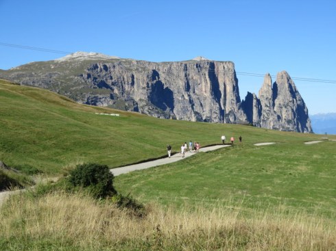
Trail #2 joins Trail #7 in short order. Turn right and follow Trail #7 with magnificent views of the Sciliar and Punto Santner to the west. Trail #7 is a road, more up than down, but it is not steep and undulates pleasantly on your way to Rifugio Molignon, aka Mahlknecht Hütte. There’s plenty of room to walk abreast and footing is easy. We rate the section from Panorama to Molignon a “2” on the Easy Hiker Scale.*

Moligon is a delightful place to stop although you may choose instead Edelweiss Hütte or Almrosenhütte as you pass them. Molignon is about 1H20M (depending on how often you stop to take pictures) from the Alpenhotel Panorama at the top of the lift. We usually arrive about 10:30 and use Molignon as a coffee/strudel/bathroom stop. Marvel that real ceramic dishes, stainless tableware, and actual glasses are used to serve housemade food, hot, fresh, tasty. Have a late morning beer like many of the locals do. Cyclists also stop here also and will head off on 8A as they are prohibited on the next section of Trail #7, but you’ll see many of them again at Dialer and some go all the way to Zallinger so you will share the path on occasion.
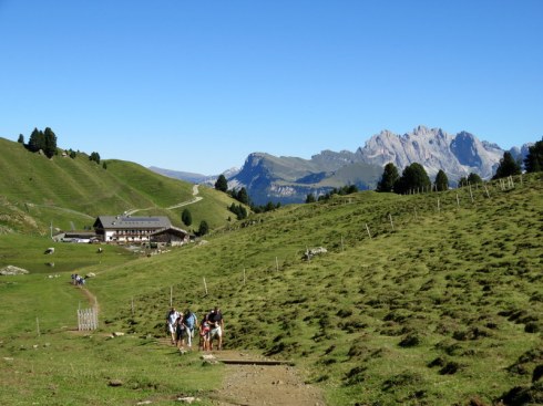
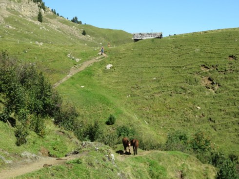
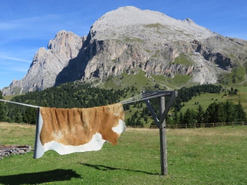
From Molignon, pass through the gate and walk past the pond, horse corral, and pasture with a herd of cows. Now the trail becomes more of a hike. You will pass over a couple of small streams, one with a bridge and one with stepping stones. Expect some dampness and mud if it has rained recently. Climbing fairly steadily, you will briefly rejoin the road (with cyclists) and reach Dialer, the highest point on the route. The chapel of Dialer Kirchl sits picturesquely against the backdrop of the Sciliar-Catinaccio.

Take a moment to savor the setting and maybe visit the chapel, then continue on Trail #7, following signs to Zallinger. The trail goes in and out of forests and the pavement varies. There are full-on views of the Sassopiatto’s flat face and occasionally a glimpse of Saltria far below. There is another tiny stream to cross. At one point, it appears you might need to hike up a steep gravel road but look for the sign on your left indicating #7 to Zallinger and follow it slightly down, then undulating, and at one point falling to a creek (with bridge). Finally, pass a farm and hike steadily up to the beckoning rifugio.

]

And what a refuge it is after this long hike! It is only 10-15 minutes to Williamshütte and the Florian chairlift down to Saltria but Zallinger offers some of the best views possible from their terrace and the food is praise-worthy, ranging from gourmet salads (try the fitness salad with turkey) to Weiner-Schnitzel or the local canaderli. Of course, there’s beer and where there is beer, a Radler is possible as well.
Refueled and rested, make your way up up up to Williamshütte (15 minutes) and the dramatic chairlift down to Saltria. From Saltria, the #11 shuttle runs roughly every half-hour to Compatsch. The last bus is at 18:55 from mid-June until mid-September, then for the next month the last bus is at 17:35. Check locally to make certain you know when the last bus departs as well as being informed about the last gondola down from Compatsch!
* Easy Hiker Scale
- Promenade – Paved or partly paved and mostly level; well-signed and generally suitable for baby carriages
- Easy hike – Unpaved, crossing hills or mountain terrain, some ups and downs, or may have minimal signage
- Extra Energy – More exertion required due to length or extended uphill segments; may have loose gravel or moderately tricky footing
- Moderately Strenuous – Longer, more challenging terrain requiring sturdy footwear and endurance. Not suitable for very young children.
Logistics
| Start: | Mountain station of the Panorama chairlift at Alpenhotel Panorama, Alpe di SIusi |
| End: | Williamshütte, mountain station for the Florian chairlift to Saltria |
| Duration: | 3H 45M |
| Difficulty: | 4* |
| Distance: | 10.1KM, 6.3 miles |
| Type of Hike: | One-way with return by bus |
| Trail #s: | 2, 7 |
| Transportation: | Bus #4 or combination of #172 and #170 from Ortisei to Cabinovia Alpe di Siusi, then 3 lifts: the Cabinovia AdS, Panorama, and Florian. Return to Compatsch by #11 Saltria Shuttle. See links to schedules below. |
| Refreshments: | Compatsch restaurants, Hotel Panorama, Edelweiss Hütte or Almrosenhütte, Rifugio Molignon, Zallinger, Williamshütte |
| WCs: | Compatsch restaurants, Hotel Panorama, Edelweiss Hütte or Almrosenhütte, Rifugio Molignon, Zallinger, Williamshütte |
| Hiking Boots? | Yes |
| Trekking Poles? | Advisable |
Helpful links:
#4 and #11 bus schedules https://www.silbernagl.it/en/timetables (updated seasonally as different services run winter and summer)
South Tyrol route planner http://www.sii.bz.it/en/siipdfOldtimetables
Discover more from Girovaga
Subscribe to get the latest posts sent to your email.

This just looks wonderful! I’m getting eager to give it a try next year!
LikeLiked by 1 person
We will be in Ortisei Sept 2-16 in case you want to hook up. 😉
LikeLike
Laurel, the views are so beautiful! Thank you so much for sharing your adventures with us.
LikeLiked by 1 person
Thanks Kathy! I know you have a holiday in Ortisei coming up. Next spring, is it? Have you been out to Saltria? Easy to do by lift and bus if you like.
LikeLike
Yes, Laurel, we will be in Ortisei at the end of May 2020. I have not been to Saltria. I will definitely put it on our list of things to do.!
LikeLike
Love the green Swiss meadows! While it is a challenging hike, the views and sense of accomplishment must make it all worthwhile!
LikeLiked by 1 person
Yes! We were a little annoyed to find 1 1/2 hours become 2 1/2 as while we are not the fastest hikers, we are not that slow, either! Lunch was late, but relished and we did feel quite proud of ourselves.
LikeLike