EDITORS NOTE: Both books were updated in 2025. Here is the link to the current edition, US site: Walking in Italy’s Val Gardena. If you are purchasing from another market (UK, DE, etc.) please go to your country’s page and be sure to look for the 2023 edition.
It has been a very busy month. Having just released our book Walking in Switzerland’s Berner Oberland on January 26, we’ve updated our book of easy hikes in Italy’s Dolomites. Walking in Italy’s Val Gardena is now available in its third — and best — edition. Just released on Amazon overnight last night, the big improvement in this edition is that it includes maps for every one of the 23 easy hikes described in the book.
We first published “Walking,” or as I like to call it “WIVG,” in early 2017. Each year we’ve made it stronger, but I am really delighted that we found a tool to help us create maps. Each hike has a printed map and a link to an online map with an elevation profile. The viewer can customize their experience by selecting the type of map (Street, Satellite, Cycling and more), zoom in to see more details, and also personalize a timer based on individual walking speed. Maps can be downloaded in eight different formats.
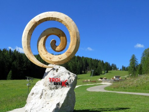
For fun, here’s one route, a very easy but delightful art walk on a small mountain called Monte Pana where views over the valley from almost 7200 feet are accompanied by an art installation. Take a look and discover the Troi Unika. (NOTE: As of 2025, we no longer recommend this walk as the trail was poorly maintained when we walked it.)
The emblem a the start of the Troi Unika, a very easy walk.
WIVG is available in paperback as well as Kindle, and if you are a Kindle Unlimited subscriber, you can read it for free. Our books are also available in Amazon Marketplaces worldwide such as Italy, the UK, Japan, and India.
EDITORS NOTE: This book was updated in 2023. Here is the link to the current edition, US site: Walking in Switzerland’s Berner Oberland. If you are purchasing from another market (UK, DE, etc.) please go to your country’s page and be sure to look for the 2023 edition.
We are delighted to announce our new e-book is live on Amazon! Walking in Switzerland’s Berner Oberland: Easy HIkes in the Jungfrau Region is designed for anyone who likes to walk, likes to be in nature, but may not have the stamina for longer, more strenuous hikes. Like our book on Italy’s Val Gardena, we’ve included hikes for children, seniors, or anyone who wants to enjoy the mountains but not climb them.
There are 13 walks, perhaps best described as light hiking. They range from 1.4 to 4.4 miles and all are under 2 hours. Some can be linked together for those desiring more activity. We also advise on transportation, which the Swiss make amazingly easy. A car is an unnecessary expense and hassle especially in this region of Switzerland.
While the Swiss offer a mind-numbing assortment of transportation passes, we explain the differences and how to determine which passes you may need.
For a taste of the book, you might enjoy our blog post from Project Easy Hiker, the Lauterbrunnen to Mürren hike from 2017. It is our #1 recommended hike for those who only have a couple of days to spend here.
We welcome your input. If you use the book and have comments, please send them to us using ProjectEasyHIker@gmail.com. If you have favorite hikes in that area that we should explore, please leave a comment here or send a note to the email address.
If you have not been to the area, think about this view and ask yourself why you haven’t gone there yet?
NOTE: In January 2025, “Walking in Italy’s Val Gardena” was published in its 6th edition and the link to Amazon was updated.
As the clouds, rain, fog, and cold temperatures descend on the Oregon Coast, I am thinking about a wonderful hike we took in September and looking forward to a repeat next September.
We pushed ourselves a bit in taking this hike as it is more ambitious than our usual fare. We reveled in our satisfaction at completing it and celebrated with a Radler over lunch. Rick Steves’ Italy guidebook sucked drew us to this hike but his directions and time estimates were terrible. (His 1H30M section was our 2H25M. We would have taken the hike anyway however an hour’s difference in the estimated time is disappointing.) I think it has been many years since anyone in the Steves’ organization took this route and updated directions.
So we did it.
Click here to buy on Amazon.com. Also available on all Amazon sites worldwide in Kindle or paperback versions.
I would include this in the next edition of our book (coming in early 2020!), but it is a little beyond the “easy hiker” scale so I offer it here, for anyone who might enjoy the option. We spent the nights before and after on the Alpe di Siusi, enjoying the luxury of half-pension at the Hotel Saltria. This hike can be done as a day trip from Ortisei, but it is a long day, at least 10 hours with transportation. We recommend a couple of nights on the Alpe di Siusi as part of a holiday in the area. Two or three nights on the Alpe di Siusi plus four or more nights in Ortisei is perfect.
Herewith, this magnificent hike as we would write it for the book. Start dreaming of an Italian hiking trip! If you are not into hiking or cannot imagine doing this, at least look at the pictures?
Panorama to Williamshütte: A grand view on the Alpe di Siusi
The route map with profile can be examined in detail and downloaded at Plotaroute. (We will be including maps for most walks in our next edition.)
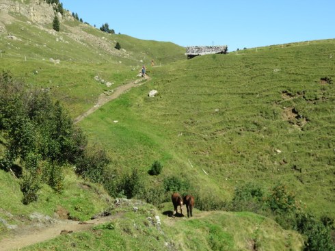
Featuring: Vast meadows, peak views near-and-far, cows, ponies, wildflowers, two dramatic chairlifts, and lovely rifugi where you can rest and refuel. The best time to take this hike is from mid-June to mid-October but be aware there can be snow in high elevations at any time which may compromise your ability to do this hike.
This hike is more strenuous than most of those in our book, Walking in Italy’s Val Gardena. In fact, we rated it a “4” on the Easy Hiker Scale* due to the varying terrain of the final two-thirds. While it starts and ends at about the same altitude, the ups-and-downs are considerable, and you will ascend 1253 feet/382 meters and descend 978 feet/298 meters.
How to arrive: Six times each day the bus #4 from Piazza Sant’Antonio goes directly to the base station of the Cabinovia Alpe di Siusi/Seiser Alm Bahn. This is your most efficient choice at 8:45, 10:00, 11:15, 14:50. 16:00, and 17:15. Note the cabinovia may not be running if you arrive on the last bus. Later in the day, use a combination of bus #172 to the bus plaza in Castelrotto and the #170 to Bivio Cabinovia (drops you a short way below the lift station and you walk up) or the combination of bus #172 and #2/3 which takes you right to the base station. Ask locally if you are confused. The bus drivers are fantastic and the route is included with the Val Gardena Mobile Card provided by your lodging host.
(NB: Bus numbers, routes, and schedules tend to be adjusted seasonally so verify times before setting out on your adventure!)
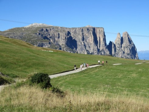
The path is wide and level as it leaves Panorama with the Sciliar and Punto Santner in view.
FYI, driving to the Alpe di Siusi is possible only before 9:00 and after 17:00 unless you have a hotel reservation and a permit for your vehicle. If you have a permit from your hotel, you can drive in at any time on your arrival day and out on your departure day, but during your stay you may only use your car before 10:00 and after 17:00. The buses are excellent, though, and parking is limited so go with the flow and take the #11 shuttle! Once at the base station (where there is lots of parking if needed), take the blue gondolas up to Compatsch where the hike begins with another lift, to Panorama. The Cabinovia Alpe di Siusi starts running at 8:00 from late May to early November. Note there are seasonal closures before-and-after ski season commences. Last ride down is 19:00! (Check locally to make sure that has not changed.)
Make your way to the base station for the Panorama lift (opens at 8:30), about a 5 minute walk down from Compatsch. At the top of the lift, pass the Alpenhotel Panorama and look for Trail #2, the start of this journey.
Mountains on the other side of the Val Gardena are visible from the trail near Edelweiss Hütte.
The route
Trail #2 joins Trail #7 in short order. Turn right and follow Trail #7 with magnificent views of the Sciliar and Punto Santner to the west. Trail #7 is a road, more up than down, but it is not steep and undulates pleasantly on your way to Rifugio Molignon, aka Mahlknecht Hütte. There’s plenty of room to walk abreast and footing is easy. We rate the section from Panorama to Molignon a “2” on the Easy Hiker Scale.*
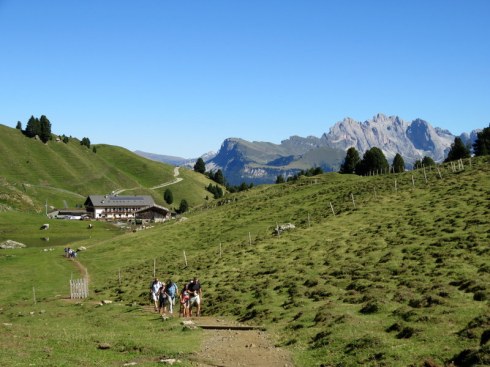
Coming into Molignon, a perfect stop for strudel.
Moligon is a delightful place to stop although you may choose instead Edelweiss Hütte or Almrosenhütte as you pass them. Molignon is about 1H20M (depending on how often you stop to take pictures) from the Alpenhotel Panorama at the top of the lift. We usually arrive about 10:30 and use Molignon as a coffee/strudel/bathroom stop. Marvel that real ceramic dishes, stainless tableware, and actual glasses are used to serve housemade food, hot, fresh, tasty. Have a late morning beer like many of the locals do. Cyclists also stop here also and will head off on 8A as they are prohibited on the next section of Trail #7, but you’ll see many of them again at Dialer and some go all the way to Zallinger so you will share the path on occasion.
Leaving Molignon, which is a working farm as well as rifugio.
After Molignon the path becomes a true trail.
From Molignon, pass through the gate and walk past the pond, horse corral, and pasture with a herd of cows. Now the trail becomes more of a hike. You will pass over a couple of small streams, one with a bridge and one with stepping stones. Expect some dampness and mud if it has rained recently. Climbing fairly steadily, you will briefly rejoin the road (with cyclists) and reach Dialer, the highest point on the route. The chapel of Dialer Kirchl sits picturesquely against the backdrop of the Sciliar-Catinaccio.
The little church at Dialer.
Take a moment to savor the setting and maybe visit the chapel, then continue on Trail #7, following signs to Zallinger. The trail goes in and out of forests and the pavement varies. There are full-on views of the Sassopiatto’s flat face and occasionally a glimpse of Saltria far below. There is another tiny stream to cross. At one point, it appears you might need to hike up a steep gravel road but look for the sign on your left indicating #7 to Zallinger and follow it slightly down, then undulating, and at one point falling to a creek (with bridge). Finally, pass a farm and hike steadily up to the beckoning rifugio.
One of the bridges crossing a creek.
]
Zallinger comes into view!
And what a refuge it is after this long hike! It is only 10-15 minutes to Williamshütte and the Florian chairlift down to Saltria but Zallinger offers some of the best views possible from their terrace and the food is praise-worthy, ranging from gourmet salads (try the fitness salad with turkey) to Weiner-Schnitzel or the local canaderli. Of course, there’s beer and where there is beer, a Radler is possible as well.
The Sassopiatto looks a lot different from this angle.
Refueled and rested, make your way up up up to Williamshütte (15 minutes) and the dramatic chairlift down to Saltria. From Saltria, the #11 shuttle runs roughly every half-hour to Compatsch. The last bus is at 18:55 from mid-June until mid-September, then for the next month the last bus is at 17:35. Check locally to make certain you know when the last bus departs as well as being informed about the last gondola down from Compatsch!
* Easy Hiker Scale
Promenade – Paved or partly paved and mostly level; well-signed and generally suitable for baby carriages
Easy hike – Unpaved, crossing hills or mountain terrain, some ups and downs, or may have minimal signage
Extra Energy – More exertion required due to length or extended uphill segments; may have loose gravel or moderately tricky footing
Moderately Strenuous – Longer, more challenging terrain requiring sturdy footwear and endurance. Not suitable for very young children.
Logistics
Start:
Mountain station of the Panorama chairlift at Alpenhotel Panorama, Alpe di SIusi
End:
Williamshütte, mountain station for the Florian chairlift to Saltria
Duration:
3H 45M
Difficulty:
4*
Distance:
10.1KM, 6.3 miles
Type of Hike:
One-way with return by bus
Trail #s:
2, 7
Transportation:
Bus #4 or combination of #172 and #170 from Ortisei to Cabinovia Alpe di Siusi, then 3 lifts: the Cabinovia AdS, Panorama, and Florian. Return to Compatsch by #11 Saltria Shuttle. See links to schedules below.
Refreshments:
Compatsch restaurants, Hotel Panorama, Edelweiss Hütte or Almrosenhütte, Rifugio Molignon, Zallinger, Williamshütte
WCs:
Compatsch restaurants, Hotel Panorama, Edelweiss Hütte or Almrosenhütte, Rifugio Molignon, Zallinger, Williamshütte
Sleep came, at last, on our sixth night at home, signifying the end of jet lag: 8.5 hours Tuesday night had me rolling out of bed at 05:00. The first full night of sleep truly puts a trip behind us except for the memories and 1100+ photos to be sorted.
The final two weeks of our trip were spent in Lauterbrunnen in our favorite apartment. This was our fourth stay in James’ and Michelle’s apartment and it felt like home when we walked through the door. We’ve already booked a stay there in Autumn 2020.
Even in our sixth visit to the area we are finding new walks, new experiences, new corners to explore.
Wrapping up this portion of our trip, I have some photos from a few of our favorite hikes in the valley and mountains. We plan to publish an e-book about easy hikes in this area. Updating the Val Gardena book and writing this new one for the Lauterbrunnen area should keep me out of trouble all winter.
The Allmendhubel to Winteregg hike starts at a fabulous playground. The children don’t seem to notice the view.
The Mountain View Trail between Allmendhubel and Winteregg is well named.
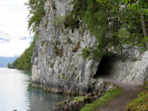
The trail from Iseltwald to Giessbach hugs the lake and goes through a short tunnel.
We had a couple of steep climbs on the way to Giessbach.
At the end of the Iseltwald to Giessbach hike, a Victorian Era hotel and a fabulous waterfall.
No matter how many times we do it, always a favorite for us is the walk from Grütschalp to Mürren with a view of the little cogwheel train. Oh, and mountains.
Another fave is Männlichen to Kleine Scheidegg. Not too difficult and highly satisfying.
We had a surprise snow overnight before our hike on the North Face Trail.
Descending at the end of the North Face Trail into Mürren. The sun came out as we hit town. We hiked alone, encountering maybe half-a-dozen people in 2.5 hours.
Our post-hike view from lunch at about 14:00. The mountain restaurants along the trail were closed for the season.
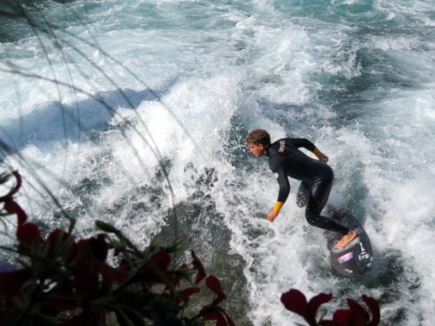
In Thun (pronounced “tune”), Switzerland, a man surfs in the wake created by sluice gates on the River Aare.
Thun is one of the larger towns in the Berner Oberland. Our walk along Lake Thun included four castles on a bright Saturday.
Spotted on a walk near Wengen. One passes from town to farm in the blink of an eye.
While weather and lighting did not cooperate to make this the stunning shot I had hoped for, it’s still a magnificent view of the Lauterbrunnen Valley and Staubbach Falls.
Another walk near Wengen. Snow overnight made higher elevation walking precarious so we found this nice walk above the valley where we could admire the fresh snow.
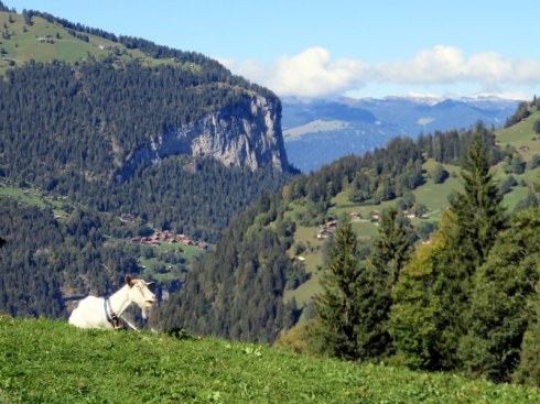
Goat pasture with a view, Wengen. In less then 30 minutes we went from touristy crowds crowding mountain trains in downtown Wengen to working farms.
If you are looking for a comfortable, convenient roost in the Jungfrau Region, send me a message and I’ll tell you how to get in touch with James. Pictures are online here but you’ll want to reach out personally rather than book through the site.
Imagine a place without traffic noise. No cars, no trains, no buses: just a breeze in the trees, a distant cowbell, the gentle whirr of a gondola. Occasionally, an electric taxi or service vehicle makes its way through the village.
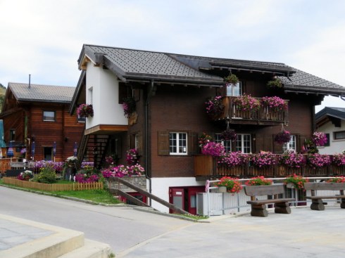
This is Bettmeralp, a tiny village where altitude (2006 meters/6581 feet) is mentioned before its population of 462.
The little “Kapelle Maria zum Schnee” (Chapel of Maria of tne Snow) as night descends. On the far right, you can see the triangle peak of the Matterhorn.
You can see the Matterhorn from Bettmeralp when conditions are right.
The village has been on my list of must-explore places in Switzerland for about three years. While many tourists flock to Zermatt, our beloved Lauterbrunnen Valley, Luzern, and the Engadine, Bettmeralp in September is almost devoid of tourists. The first night in our hotel, the Waldhaus, only three rooms of this medium-sized family hotel were occupied. The next night, the shoulder season brought a group of 17 to stay for an entire week of alpine exploration.
It was quiet even with so many guests.
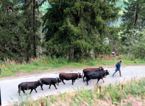
The loudest noise we heard in 3 nights at the Hotel Waldhaus was this “cow parade” right below our window.
This is hiking country, with several trails offering views of the famous Aletsch Glacier, worth seeing before climate change takes even more of a toll. The Aletsch Arena is quite different from our usual haunts in the Berner Oberland. Bettmeralp sits at and above the tree line surrounded by massive snowy peaks too numerous to name. The light is constantly changing and the village is, like most Swiss villages, bedecked with flowers. It is picturesque, to say the least.
The view from our room at the Hotel Waldhaus at sunrise.
Bettmeralp, nestled high above the valley.
Flower-bedecked, the buildings look lovely even on cloudy days.
We only had two days to hike and one could certainly spend several days exploring more corners of the Aletsch Arena by train, lift, and on foot. We choose to start a rainy day by heading on the paved path to neighboring Riederalp. We were looking for one of the lifts in that small village and could not find it in the fog. We were astonished when after seeking refuge in a cafe for a warming cup of espresso we emerged to find the clouds had broken and the landscape revealed to us again.
The signage is good: you won’t get lost but you might be confused at the options.
The second day we traveled by train and gondola to Fiescheralp, almost deserted now in the shoulder season but clearly a major ski-holiday destination. The exposed path we took back to Bettmeralp bore few fellow travelers this late in the fall but the vistas were, once again, magnificent and this hike, in particular, gave us a more complete picture of the area.
On the road from Fiescheralp, a beautiful view.
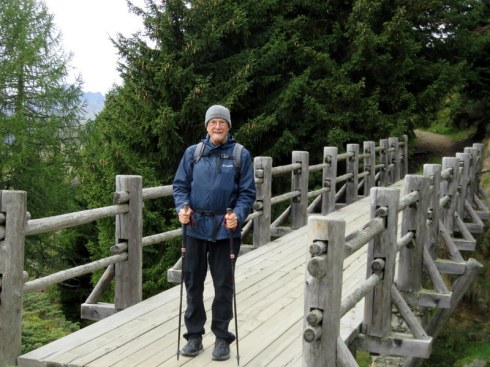
Ric crosses a bridge on our hike from Fiescheralp to Bettmeralp. Yes, it was cold enough for a tuque.
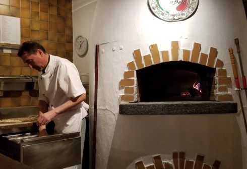
To top off the magnificent scenery, we found excellent pizza as well. Paolo, the pizzaiolo at Pizzeria PiccoBello told me that there are many Italians in the area, working on the lifts. (Italians were also employed in the creation of some of Switzerland’s amazing tunnel systems.)
A lovely Italian experience, high in the Swiss alps.
One of our pies at PiccoBello. Truly Italian but with a Swiss-style sausage. The crust was top notch!
Paolo the pizzaiolo plies his trade. A delicate crust that stands up to the sauce and toppings. An art form aided by a wood-fired oven.
The Waldhaus fed us well the other two nights as we partook of their excellent half-board. Mamma mia what a feast: 5 courses! Luckily portion-size was rational. Their selection of Swiss wines gave us a chance to enjoy products seldom found outside of the country.
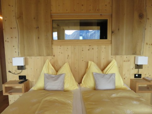
We had a moonwood room at the Waldhaus. Above the bed, a window leads from the shower room. Shower with a view!
This is the view from our shower room at the Waldhaus.
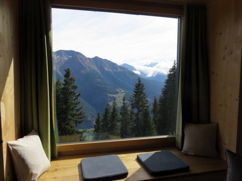
A little nook in the room at the Waldhaus with a gorgeous view, ever-changing light.
We parted somewhat reluctantly after three nights. An additional night-or-two would have allowed us to visit the pristine alpine lakes or ride lifts to see the glacier from a couple of additional viewpoints.
There’s always “next time!”
Outside the Hotel Waldhaus where were were made to feel very welcome indeed.